|
|
|
 |
Compass Rose
 It
was during the Age of Exploration that
cartographers began to implement a
common standard depicting compass
headings in relation to the
representation on the map. This
new innovation was often referred to as
the "Compass Rose". It
was during the Age of Exploration that
cartographers began to implement a
common standard depicting compass
headings in relation to the
representation on the map. This
new innovation was often referred to as
the "Compass Rose".
A compass rose is a figure
displaying the orientation of the
cardinal directions, north, south, east
and west on a map or nautical chart. It
is also the term for the graduated
markings found on the traditional
magnetic compass.Today the use and idea
of a compass rose is found on or
featured in almost all navigation
systems, including nautical charts, NDB
and VOR systems, some GPS sets and
similar. In ancient times, however
maps were typically drawn from whatever
perspective the map maker preferred, and
North was rarely aligned with the top
edge.
 Although a compass rose may sometimes be
called a wind rose, it should not be
confused with the graphic tool used by
meteorologists to depict wind
frequencies from different directions at
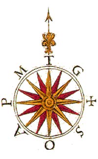
a location. A Rose of the Winds
(right) is actually an ancient
version of a compass rose which
personified compass directions as winds
with individual names, such as the west
wind Zephyrus and the east wind Eurus. Although a compass rose may sometimes be
called a wind rose, it should not be
confused with the graphic tool used by
meteorologists to depict wind
frequencies from different directions at
a location. A Rose of the Winds
(right) is actually an ancient
version of a compass rose which
personified compass directions as winds
with individual names, such as the west
wind Zephyrus and the east wind Eurus.
On these designs, north is traditionally
indicated with a "fleur de lis" symbol,
while East (with its religious and
cosmological significance, the direction
of Jerusalem) is often marked with a
Maltese cross, as it is seen in the
graphic below.
 Shown
on the left is a replica of a 32-point compass rose from
a chart by Jorge de Aguiar (1492), the
oldest personally signed and dated
Portuguese nautical chartNaming all 32
points on the rose is called boxing the
compass. Shown
on the left is a replica of a 32-point compass rose from
a chart by Jorge de Aguiar (1492), the
oldest personally signed and dated
Portuguese nautical chartNaming all 32
points on the rose is called boxing the
compass.The "rose" term arises from the fairly
ornate figures used with early
compasses. A fleur-de-lis figure,
evolved from the initial T in the north
wind's name Tramontane, is sometimes
used to indicate the north direction.
Similarly, on old maps the east was
marked with an L for Levante, or with a
+ indicating the direction of Jerusalem
from the point of view of western
Europe's countries.Early roses were depicted with 12 points
at 30° each, as was favored by the
Romans. In the Middle Ages map makers
moved to the 16-point rose complaining
that sailors did not have the education
to understand the previous design. The
16-point rose has the uncomfortable
number of 22 1/2° between points, but is
easily found by halving divisions and
may have been easier for those not using
a 360° circle. Using gradians, the
sixteen-point rose will have exactly
twenty-five gradians per point in.
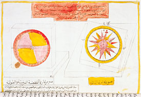 The
earliest known examples of a 32-point
compass rose was developed by Arab
navigators during the Middle Ages. The
earliest known examples of a 32-point
compass rose was developed by Arab
navigators during the Middle Ages.
An example of an early Arabic compass
rose is shown on the right.
In the classical world, no distinction
was made between the directions and the
named winds emanating from them. Wind
names were not standardized (not every
region in the classical world
experienced the same wind coming from
the same direction) and vary by the
literary source (though names are
relatively more standardized for the
four cardinal directions). Of
note, a
fountain in Taranto, Italy was inspired
by and named after the Rose of the
Winds.
 The
modern
compass rose appears as two rings, one
smaller and set inside the other. The
outside ring denotes true cardinal
directions while the smaller inside ring
denotes magnetic cardinal directions. The
modern
compass rose appears as two rings, one
smaller and set inside the other. The
outside ring denotes true cardinal
directions while the smaller inside ring
denotes magnetic cardinal directions.
True north refers to the geographical
location of the north pole while
magnetic north refers to the direction
towards which the north pole of a
magnetic object (as found in a compass)
will point.
The angular difference
between true and magnetic north is
called variation, which varies depending
on location. The angular difference
between magnetic heading and compass
heading is called deviation which varies
by vessel and its heading. |
Click on the Piece of Eight to return to the Main Page
 |
|
 |
|
|
|